
Hurricane Sam
Forecasters call for Hurricane Sam, a potent storm spinning over the Atlantic Ocean, to steer clear of land. But some areas are still likely to witness the effects of the storm, from high winds in Bermuda to dangerous waves and currents at beaches up and down the U.S. East Coast.
From their perch on the International Space Station (ISS), astronauts have a unique view of the vast size of such storms. An astronaut shot this photo (above) of Hurricane Sam marching across the Atlantic Ocean on September 29, 2021.
The next day, NASA’s Earth Polychromatic Imaging Camera (EPIC) on NOAA’s DSCOVR satellite, captured an even wider view (below). This image shows Hurricane Sam on September 30 when it had sustained winds measuring 230 kilometers (145 miles) per hour (a category-4 storm). The storm was located about 1,000 kilometers southeast of Bermuda and moving northwest.
The forecast track called for Sam to turn north and then northeast, with its center passing east of Bermuda and staying well away from the coast of the United States. Scott Braun, a scientist who specializes in hurricanes at NASA’s Goddard Space Flight Center, pointed out a frontal system responsible for pulling Sam toward the north, visible in the EPIC image. “The cold front extends from well north of Sam (in the north-northeast direction) to the west of Sam, as seen in the bright, but somewhat broken clouds along the front.”
The image also shows that Sam is not alone. Tropical Storm Victor was located about 1,000 kilometers southwest of the Cabo Verde islands and moving toward the west-northwest. Winds in this storm were much weaker, holding steady at 75 kilometers (45 miles) per hour. Forecasts call for Victor to remain a tropical storm for a few days and then weaken into a tropical depression.
Strong wind shear, which can tear apart a storm’s organization, is one reason why Victor is expected to weaken. The storm is also trailing a plume of Saharan dust blowing west from North Africa. Such dust outbreaks tend to be accompanied by dry air, which can weaken or even stop a storm.
From their perch on the International Space Station (ISS), astronauts have a unique view of the vast size of such storms. An astronaut shot this photo (above) of Hurricane Sam marching across the Atlantic Ocean on September 29, 2021.
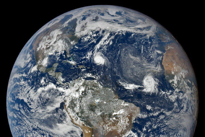
The next day, NASA’s Earth Polychromatic Imaging Camera (EPIC) on NOAA’s DSCOVR satellite, captured an even wider view (below). This image shows Hurricane Sam on September 30 when it had sustained winds measuring 230 kilometers (145 miles) per hour (a category-4 storm). The storm was located about 1,000 kilometers southeast of Bermuda and moving northwest.
The forecast track called for Sam to turn north and then northeast, with its center passing east of Bermuda and staying well away from the coast of the United States. Scott Braun, a scientist who specializes in hurricanes at NASA’s Goddard Space Flight Center, pointed out a frontal system responsible for pulling Sam toward the north, visible in the EPIC image. “The cold front extends from well north of Sam (in the north-northeast direction) to the west of Sam, as seen in the bright, but somewhat broken clouds along the front.”
The image also shows that Sam is not alone. Tropical Storm Victor was located about 1,000 kilometers southwest of the Cabo Verde islands and moving toward the west-northwest. Winds in this storm were much weaker, holding steady at 75 kilometers (45 miles) per hour. Forecasts call for Victor to remain a tropical storm for a few days and then weaken into a tropical depression.
Strong wind shear, which can tear apart a storm’s organization, is one reason why Victor is expected to weaken. The storm is also trailing a plume of Saharan dust blowing west from North Africa. Such dust outbreaks tend to be accompanied by dry air, which can weaken or even stop a storm.
earthobservatory.nasa.gov

