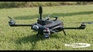
SmartDrone to Showcase New Discovery Drone Platform at AUVSI Xponential 2021
SmartDrone, a manufacturer of small industrial drones for surveying, civil engineering, and earthwork, announced today that it will be showcasing its new Discovery Drone at AUVSI Xponential in Atlanta, Georgia from August 16th to 19th, 2021. The Discovery Drone is a fully automated, aerial collection platform featuring high-resolution Ouster digital lidar that is designed to augment traditional earth measuring.
The Discovery offers customers fast paybacks and significantly increases productivity in the field by as much as ten times. Additionally, customers can view results in the field in real-time with the company’s one-click processing suite.
“We are incredibly excited to showcase the new Discovery Drone which represents a major step-change from traditional mapping to digital, lower-cost, and more efficient surveying. I have spoken with hundreds of land surveyors who all agree that drones and accessible aerial lidar are the next big evolution in earth measuring. Our partnership with Ouster allows us to offer a durable drone solution and high-quality data to our customers for fast one-foot contours,” said Rob Cammack CEO for SmartDrone.
SmartDrone will be showcasing the Discovery Drone with Ouster at booth #3548 at AUVSI’s Xponential 2021. To learn more about the accessibility and disruptiveness of Discovery, check out this media kit and to see it in action watch this video.
About SmartDrone
SmartDrone is passionate about revolutionizing how we see the world and disrupting the industrial drone industry with accessible aerial solutions. The company manufactures small industrial drones and works with leaders in land surveying, civil engineering, and earthwork who are responsible for data collection and delivery. The SmartDrone solution provides accurate data 10X faster than traditional methods and lets customers keep control of their data. The Discovery drone platform was designed from the ground up to easily augment traditional field crews and import easily to modern CAD workflows. To learn more, visit www.smartdrone.us or connect with us on LinkedIn or YouTube.
The Discovery offers customers fast paybacks and significantly increases productivity in the field by as much as ten times. Additionally, customers can view results in the field in real-time with the company’s one-click processing suite.
“We are incredibly excited to showcase the new Discovery Drone which represents a major step-change from traditional mapping to digital, lower-cost, and more efficient surveying. I have spoken with hundreds of land surveyors who all agree that drones and accessible aerial lidar are the next big evolution in earth measuring. Our partnership with Ouster allows us to offer a durable drone solution and high-quality data to our customers for fast one-foot contours,” said Rob Cammack CEO for SmartDrone.
SmartDrone will be showcasing the Discovery Drone with Ouster at booth #3548 at AUVSI’s Xponential 2021. To learn more about the accessibility and disruptiveness of Discovery, check out this media kit and to see it in action watch this video.
About SmartDrone
SmartDrone is passionate about revolutionizing how we see the world and disrupting the industrial drone industry with accessible aerial solutions. The company manufactures small industrial drones and works with leaders in land surveying, civil engineering, and earthwork who are responsible for data collection and delivery. The SmartDrone solution provides accurate data 10X faster than traditional methods and lets customers keep control of their data. The Discovery drone platform was designed from the ground up to easily augment traditional field crews and import easily to modern CAD workflows. To learn more, visit www.smartdrone.us or connect with us on LinkedIn or YouTube.
www.valdostadailytimes.com