
Preserving Cultural Heritage: Drones used for 3D modelling of Shenyang Imperial Palace
The Shenyang Imperial Palace in northeast China is considered the most ancient architectural complex of the Qing Dynasty – second to the Forbidden City in Beijing. In recent years, experts have been using high-tech tools, such as drones and 3D modelling for preservation efforts of the major relic from Imperial China. Yu Li tells us more.
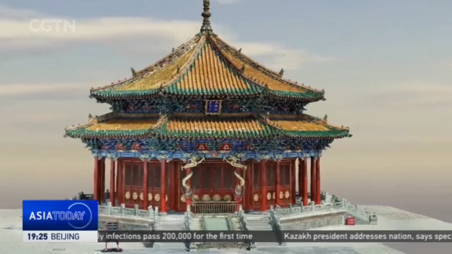
YU LI Shenyang, Liaoning Province “We’re at the Shenyang Imperial Palace, a UNESCO world Heritage site. The drone is ready to take off to collect data for building a three-dimensional model of the Dazheng Hall, the main building served for important ceremonies in Qing Dynasty.”
The digitalization of an ancient structure in the making. The drone is taking in as much details as possible by capturing large amounts of photos around the hall. It has recorded more than 4-thousand images from different angles and positions. Data conversion, at this level, would need high processing power.
XIA XINYU Engineer, Shenyang Geotechnical Investigation & Surveying Research Institute Co. “Each green spot here represents a picture taken by the drone. The location of each photo is obtained through high-precision GPS. The accuracy is at a centimeter level.”
This is a digital version of the relics. The model shows every detail, including patterns on the wall and even exact coordinates of the building. Dun Limin says cutting-edge technology facilitates fundamental work for the preservation of cultural relics.
DUN LIMIN President, Shenyang Geotechnical Investigation & Surveying Research Institute Co. “The remote sensing images provide data for the early-stage resettlement of cultural relics. Three-dimensional laser scanning and unmanned aerial vehicles’ close-range photogrammetry can help create ‘digital twins’ of historical sites. Surveying and mapping information can provide a full chain of data for cultural heritage protection.”
YU LI Shenyang, Liaoning Province “There are growing concerns over damages to historical sites due to extreme weather. Social unrest, theft, and illicit excavations are other potential threats to cultural heritage sites. And its efforts like digitalization that can help preserve, or even restore them. Yu Li, CGTN, Shenyang, Liaoning Province.”
news.cgtn.com


