Skip to content
A4 civilengineering
  • Home
  • About Us
  • Education
  • Community
  • Thought
  • Ongoing Happenings
  • Contact Us
Menu Close

Blog

  1. Home>
  2. Remote Sensing>
  3. China launches new remote sensing satellite into orbit
China launches new remote sensing satellite into orbit
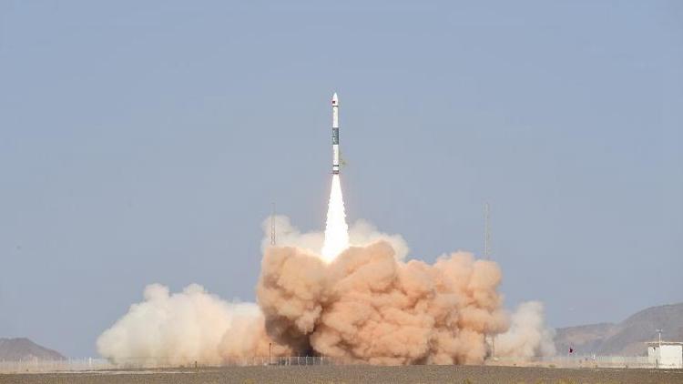
China successfully sent a satellite into preset orbit from the Jiuquan Satellite Launch Center in northwest China on Monday.

The satellite, known as Jilin-1 Gaofen 02D, was launched by a Kuaizhou-1A, or KZ-1A, carrier rocket at 2:19 p.m.

This is China’s 11th mission using the KZ-1A carrier rockets.

Read More
news.cgtn.com

Read more articles

Previous PostGeographical Information Systems and Remote Sensing event
Next PostLandsat Earth observation satellite launched into orbit

You Might Also Like

UMASS AMHERST-LED REMOTE SENSING WORK WINS .5 MILLION NASA CONTRACT

UMASS AMHERST-LED REMOTE SENSING WORK WINS $4.5 MILLION NASA CONTRACT

January 1, 2022
Satellites View California Oil Spill

Satellites View California Oil Spill

October 16, 2021
Explainable machine learning models of major crop traits from satellite-monitored continent-wide field trial data

Explainable machine learning models of major crop traits from satellite-monitored continent-wide field trial data

October 16, 2021

Archives

  • April 2026
  • March 2026
  • February 2026
  • January 2026
  • December 2025
  • November 2025
  • October 2025
  • September 2025
  • August 2025
  • July 2025
  • June 2025
  • May 2025
  • March 2022
  • February 2022
  • January 2022
  • December 2021
  • November 2021
  • October 2021
  • September 2021
  • August 2021
  • July 2021

Categories

  • 3D Printing
  • Air Quality
  • Architecture
  • Automation
  • BIM
  • Civil Software
  • Computer Vision
  • Constrcution Site
  • Digital Twin
  • Disaster
  • Earthquake
  • Edu Resource
  • Environmental
  • FreeCourse
  • Geotechnical Engineering
  • GIS
  • Industry News
  • Intelligent Transportation System
  • IOT
  • Market Analysis
  • Project Management
  • Remote Sensing
  • Sensors
  • Smart City
  • Smart Home
  • Smart Home/Building
  • Smart Materials
  • Structural Engineering
  • Structural Health Monitoring
  • Transportation
  • Uncategorized
  • Urban Planning

Recent Posts

  • Why Avr Programming Tutorial This Week and the Impact of Supporting
  • Komatsu construction equipment delivers more than muscle
  • Inside Data Science Vs Ai Sparks Debate and the Impact of Let’s
  • McKinsey and Alice Technologies form alliance
  • Duncan-Parnell Joins GeoCue Global Distribution Network to Expand Access to TrueView LiDAR and LP360 Software Across the Southeast
A4 civilengineering
©2021 Privacy policy
  • Home
  • About Us
  • Education
  • Community
  • Thought
  • Ongoing Happenings
  • Contact Us

Enjoying the contents?

Subscribe to our weekly newsletter